Happenings throughout History along The Oxford Canal

So, I spent a day trawling through The Oxford Times and Oxford Mail archives looking for stories and tales to do with The Oxford Canal, and I owe Chris McDowell (resident archivist and man everyone wants on their team in a pub quiz) a great big thank-you for all of his help and patience with me – he’s a brilliant man!

Anyway, below is a list of some of the places where interesting ‘happenings’ have taken place along the canal as it flows towards, and passes through Oxford city centre – there were plenty more stories littering other parts of this 78-mile-long stretch of waterway, but as this exhibition is taking place in Oxford I’ve decided to keep it local. I’ve also made the decision not to include the dates of the occurrences, or details of the occurrences that would enable people to date them, as the point of Wait ’til it Settles is that there’s more to this canal than meets the eye. History has made the canal what it is today, the good, the bad and the ugly – the underlying stories that have carved out its meandering shape, its physicality, its locks, its railings, its paths, its warning signs, its lifebuoys, its beauty spots, its cottages, its cottaging!

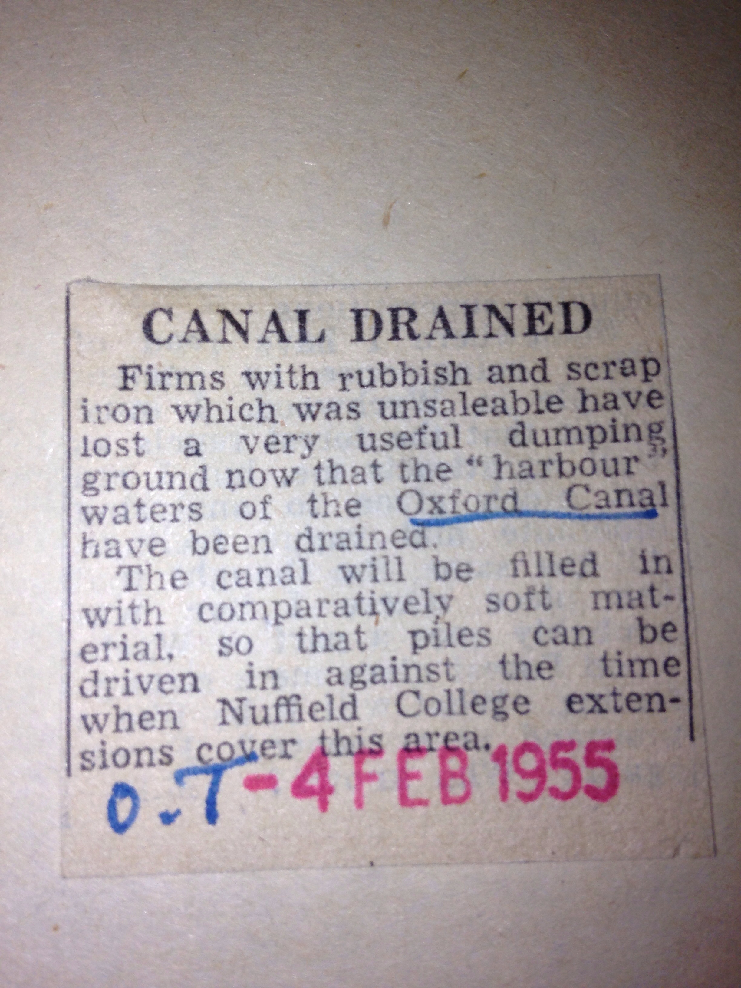
  • Drained – Canal Basin (under Worcester Street Car Park)
  • Body found – Isis Lock (or Louse Lock)
  • Dangerous condition – Wolvercote Lock
  • Girl attacked – near St Barnabas Church, Jericho
  • Natural beauty – Wolvercote (between Dukes Cut and Thrupp)
  • Soliciting – Canal Towpath (near Hythe Bridge Street)
  • Sewerage spill – Downstream from Kidlington
  • Pollution killing fish – Hythe Bridge Street
  • Dredging – Between Frenchay Road and Isis Lock (or Louse Lock)
  • Dynamite sticks found floating – Aynho
  • Birth on a boat – Swinford Bridge
  • Litter – Upper Fisher Row
  • Natural beauty – Shipton Weir Lock
  • Fatal accident – Shipton-on-Cherwell
  • Oil slick – Jericho
  • Commercial traffic – Enslow Wharf
  • Towpath charges – Godstow

Water from some of these locations will be displayed at The Jam Factory from 1st to 28th April 2014 as part of the Inspired the Canal exhibition.

In other news, here’s a list of interesting Oxford-canal based resources that I’ve happened across online in the last week:


20140329-084316.jpg

Resources – The Oxford Canal

A useful list of links and info from Oxford-based historian, canal dweller and Mr www.oxfordwaterwalks.co.uk, Mark Davies…

“Dear Sarah,

I am responding to the message you left with JLHT, in respect of source information about the Oxford Canal. Sadly, there is no handy map – it’s something we pondered as part of the Project, but have had to put off until later this year – but you will find maps in the Nicholson’s Cruising Guide to the whole canal, for instance.

As for information, I imagine that you will find my own book A Towpath Walk in Oxford helpful, as too The Oxford Canal by Hugh Compton. Both are available from the library, along with other titles that you may find helpful.

You might like to note that I am giving a talk at the Jam Factory on April 27th, incidentally:

The Oxford Canal: an artistic history

2.30pm, Sunday 27 April 2014, The Jam Factory, 27 Park End Street.
Free illustrated talk, one hour including questions.

From the industrial origins of the Oxford Canal to its modern leisure-based revival, artists have have provided an invaluable supplement to the historical record of Oxford’s resilient ‘half-town, half-country’ waterway. As part of the Oxford Canal Heritage Project, Oxford local historian Mark Davies will expand on the varied themes revealed in two centuries of paintings, drawings, and engravings, including traditional narrowboat decoration and artwork related to more recent campaigns to save the Canal and its facilities from closure.

Mark”

20140319-084829.jpg

I’m also off to Oxfordshire Newsquest HQ later this week to scour their archives for Oxford Canal based stories – looking forward to that!

More info about the Inspired by the Canal exhibition here

The history of the Oxford Canal

The below information has been swiped from the hugely informative Canal River Trust website where you’ll find a whole host of other interesting canally stuff including competitions and tips on days out aboard a canal boat.

The Oxford Canal is amongst the earliest of cuts in the Canal Age. It was initially designed by James Brindley, succeeded by Samuel Simcock and Robert Whitworth after Brindley’s untimely death in 1772 at the age of 56.

It was opened in sections between 1774 and 1790 with the purpose of bringing coal from the Coventry coalfields to Oxford and the River Thames. The canal formed part of Brindley’s grand plan for a waterway ‘cross’ linking the rivers Thames, Mersey, Trent and Severn.

The Oxford Canal provided a direct link with London via the Thames, and for several years was hugely profitable. The arrival of the Grand Junction Canal, linking Braunston to London and later becoming the backbone of the Grand Union Canal, finally broke its stranglehold and effectively bypassed the southern half of the Oxford Canal.

Nonetheless, it brought more traffic to the northern section, which soon required upgrading. The Oxford Canal was originally built to the contour method favoured by Brindley, which not only meant that the level remained fairly constant, but that the canal could call at many villages and wharves along the route. The drawback to this approach was lengthy transit times.

Boating at Braunston

In the 1830s, Marc Brunel and William Cubitt made the most of developments in engineering to straighten Brindley’s original line. Several of the resulting ‘loops’, where the new line bisected the old, can still be seen: some have found use as tranquil moorings. Other improvements included the duplication of locks at Hillmorton, and widening on the stretch between Napton and Braunston, where the canal shares its route with the modern-day Grand Union.

But the southern section between Napton and Oxford remains remarkably unspoilt and offers an evocative insight into canal life as it would have been two centuries ago. Trade began to seriously decline on the Oxford after World War II, but commerce continued well into the 1960s.

Tooley’s Boatyard, in Banbury, is famous as the spot from where canal pioneer Tom Rolt set out on his 1930s journey around the waterways. His travels in Cressy were immortalised in the book Narrow Boat, which directly led to the formation of the Inland Waterways Association and the campaign to save the waterways. The boatyard has recently been reborn as the centrepiece of the Castle Quays shopping development.

The historic Oxford terminus of the canal is long lost, sold to Nuffield College and redeveloped as a public car park. However, support is growing for proposals to reinstate it as the heart of a new cultural quarter for the city.

…………

What I need to do now, is figure out which points along the canal I’m going to collect water from. I’d like to have about 20 points to choose from, some of them recently renovated, others as old as they get. Some fast-flowing, others as stagnant as possible – please email me with any suggestions (sarah@sarahmayhewcraddock.com)